Creation of a zone system
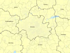
For the Munich Metropolitan Area, consisting of the cities of Munich, Augsburg, Ingolstadt, Landshut, Rosenheim and their respective suburbs, a zone system was created. The challenge were three requirements:
- Zones in urban areas were supposed to be smaller, and zones in rural areas needed to be larger.
- All zones had to nest within the boundaries or municipalities, as most socio-demographic data are provided at the zone level
- The process had to be automated to avoid tedious (and error-prone) manual work.
This automated process is now available on Github as an open-source tool that dynamically creates raster cells that nest within municipal boundaries. The user can set the desired number of zones, and the algorithm will iterate automatically to find the appropriate zone sizes.
Pre-processing scripts are also provided to generate input data from aggregated municipal statistics, and ALKIS® land use data.
The software is freely avaliable for download and modification. Further details on the design of the zoning algorithm, as well as installation and execution instructions are provided on Github in the Readme. We would appreciate any feedback or recommendations for improvements to the tool.
The program, known as pyGr, is python port of the gradual zoning algorithm gr, developed to automatically define optimally sized zones based on rasters of population and employment data.
The original gr model documentation can be found here: Moeckel, R., Donnelly, R. (2014) Gradual Rasterization: Redefining the spatial resolution in transport modeling. In: Proceedings of the 93rd Annual Meeting of the Transportation Research Board (TRB). Washington, D.C. January 12-16, 2014. [available for download at: http://moeckel.github.io/rm/doc/2014_moeckel_donnelly_trb.pdf]

