
TUMDOT-MUC
Trajectories from Urban Multimodal Drone Observations of Traffic – Munich
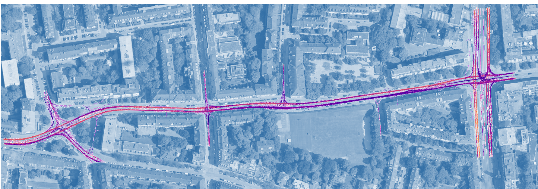
The TUMDOT-MUC dataset contains trajectories from videos recorded with drones in Munich, Germany, in October 2022. A total of 12 drones were used to observe 6 spatially continuous locations for more than 3 hours each on two weekday afternoons. The spatially and temporally linked data from the 700 m long section along Rheinstraße is currently in the final phase of post-processing. The second recording day (October 12) is now available and can be downloaded. The first day will be published soon.
The data is provided as csv files with a length of 10 minutes per file. The data is merged temporally and spatially with unique track IDs for each object. The recordings were made at 25 frames per second, with the analysis taking place every second frame. Accordingly, a new timestamp is available every 0.08 seconds. The timestamp is provided in seconds relative to the first time all drones were in the air. Timestamp 0 therefore corresponds to the time 14:59:25. The position is specified as a offset relative to the reference point (692009.0, 5338095.0, 0.0) in the UTM 32 N coordinate system and refers to the center of the object on the ground. In addition, the dimension of the object bounding box in meters, the speed in m/s and the acceleration in m/s² in the global coordinate system as well as the orientation in the form of a rotation vector are available. The object category is specified as a numerical number. The assignment of the numbers to the object categories, as well as some meta information can be found in the "meta_information.json" file.
There are known issues with the dataset, which are listed below:
- Due to technical errors and the high complexity of coordinating the exchange in the air, there are isolated gaps in the data. These can be seen from the publication.
- Due to the vertical view of the drones from an altitude of about 110 m, obstructions by trees and a construction site occurs. Especially around Bonner Platz and along the northern part of Rheinstraße, bicycles and pedestrians were thus not continuously tracked. The obstructed areas are also shown in the publication.
- Due to the high flying altitude, people walking in groups, as well as two (or more) people walking very close to each other, are often not correctly classified per individual. The tracking IDs are swapping and jumping between pedestrians, so the data here should not be used for in-depth analysis of people walking in groups.
- Due to the minimal time offset between the individual videos and the fact that spatial merging is not always completely correct, there are (sometimes) small jumps in the trajectories at the video transitions.
A detailed description of the data set can be found in the Data Science for Transportation Journal: https://link.springer.com/article/10.1007/s42421-024-00101-5
The data are available as open source for research/non-commercial use (Creative Commons CC BY-NC 4.0 license).
We encourage you to use this unique data set for your own research on the condition that the creator is appropriately credited. Therefore, for any publication and research that utilizes the TUDOT-MUC dataset, please add
“Data source: TUMDOT-MUC https://www.mos.ed.tum.de/en/vt/research/data-sets/tumdot-muc” in the acknowledgment section and also include a reference to our descriptive publication:
Kutsch, A., Margreiter, M. & Bogenberger, K.: TUMDOT–MUC: Data Collection and Processing of Multimodal Trajectories Collected by Aerial Drones. Data Science for Transportation, 6, 15 (2024). https://doi.org/10.1007/s42421-024-00101-5
Please do not hesitate to contact us if you have any questions, problems or further ideas to improve the data quality. Please contact Alexander Kutsch directly (alexander.kutsch(at)tum.de)
This dataset was created with the help of FairFleet GmbH (flying the drones), DeepScenario GmbH (extracting the trajectories) and 3D Mapping Solutions (HD-Map) - many thanks to all our partners!